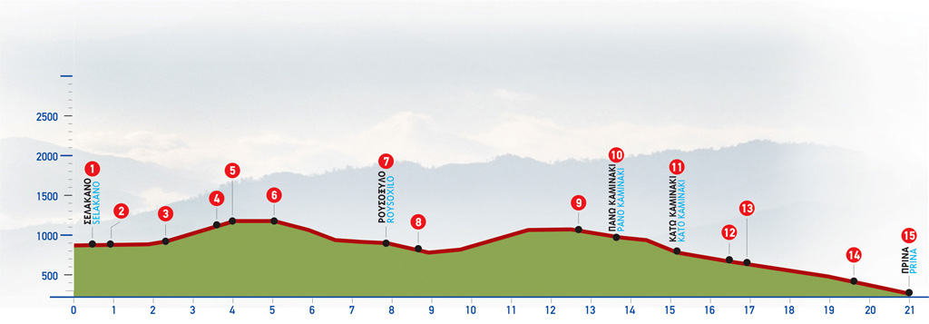
76 Selakano – Prina
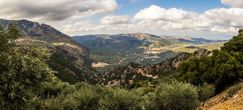
The forest of Selakano is arguably one of the most important ecosystems in Crete and is located about 20 km off the coast and the South Cretan Sea. The wild pine forest is situated between the peaks of Afendis Christos on the west (2141 m), and Spathi on the north (2148 m) and is a protected apiculture area. It has also given its name to a small village in the north exit of the forest that is the starting point of the E4 trail route. There are also established routes within the forest that are mostly used by beekeepers.
The route from Selekano to Prina
Approximately 350 m east of the village cafenio (1) and the church of Selakano, the road forks (2) and we take its north-eastern branch. After 1,3 km on an unsurfaced road, we come to a small dry stream which runs through a hollow, south of the summit of Koreli. Having crossed the dry stream (3) we leave the dirt road and climb up the slope parallel to the stream, following a vague path, initially through abandoned cultivated land and then through areas of dense pine.
As we continue, 25 minutes (approximately 1.300 m) after the unsurfaced road, we go north-west of an old, abandoned farmhouse (4) and continue to climb for about 300 m, through pine trees, until we come upon another dirt road (5). We can also see the branch of the E4 path that comes from the Katharo Plateau. A magnificent view of the valley of Selakano opens up behind us. We next follow the unsurfaced road southwards for approximately 600 m, pass a characteristic summit on its northern side and turn left on the first fork we reach (6). The right-hand, downhill branch leads south to the village of Males, with its impressive Byzantine churches.
Following on our path to Prina, the dirt road goes along a mountain slope and after approximately 1.000 m we pass through a pine-forested area. We cross a stream and then turn south-east. The dirt road leads us to an area called Roussoxila, among the farmhouses of a small plateau with vineyards and other cultivations (7). Above the houses, on the slope, there is the small chapel of Michail Archangelos (the Archangel Michael) and, nearby, a water spring with drinking water. At this point, the view to the south is magnificent.
We continue for approximately 250 m (passing by a turn-off that leads to Males on our right) (8) and then begin to climb in a due easterly direction, ignoring firstly a right-hand side road and then a left-hand one; we soon arrive at a pine-forested flat area (9), in a fold of the hillside. We begin to descend, and distant views of the Cretan Sea, northwards, as well as of the Libyan Sea, southwards, open up ahead of us. After a while, we reach a small flat area with vineyards and a stone wall, at a location called Pano Kaminaki (10), on our left. We next arrive at Kato Kaminaki (11), a small flat area with orchards and vineyards. In the middle of the plateau, on the left side of the road, there is a well with drinking water.
On the slope, there are houses used seasonally by farmers who cultivate the land of the area. We continue downhill on the dirt road eastwards; we then come to a small flat area with vineyards and almond trees and on our right-hand side we distinguish an old farmhouse, on the slope of a low mountain.
Approximately 1,5 km after Kato Kaminaki, we reach a spot with vineyards north of a small plain (12), surrounded by low pine-clad slopes. Having passed through a small saddle east of the flat area, we come to a smaller flat area with vineyards, south of which there is a turn-off (13) on our right, which we follow. We continue on the main dirt road which snakes on a slope north of a small stream, ignoring several side roads that we come by.
In a relatively flat area, the unsurfaced road passes by a small church; approximately after 400 m, we reach an asphalt road, at a spot where an old stone building (14) can be seen on our left. We take the asphalt road eastwards (left) and after 2 km we arrive at the small village of Prina (15).
| Path Length | 18 km |
|---|---|
| Hiking Duration | 5.5 hour |
| When to hike | Spring, Autumn, Summer, Winter |
| Path Region | Lassithi |