72 Varsami – Selakano
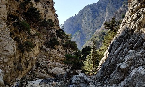
The Dikti mountain range in eastern Crete has impressive and stunning peaks for hiking and outdoor enthusiasts to explore. One of them is Varsami, which stands at an altitude of 1545 m. The Dikti mountain range is a protected ecological zone with vital wild flora and fauna. The path towards the forest of Selakano, one of the most important ecosystems in Crete, offers the chance to explore the stunning scenery of the Cretan mountainscapes.
The route from Varsami to Selakano
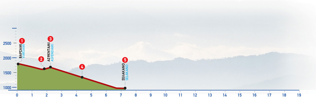
From the peak, we return to the saddle (1) before the Varsami water spring; from here we continue eastwards, on the main path, and then pass onto a low ridge. A mitato (shepherd’s stone dairy hut) can be seen on the opposite, northern slope, south of the low ridge. This is a great shelter area if needed. From this point on, we take a due north-easterly course; after approximately 2 km we reach the summit of Spathi, the highest peak at 2148 m.
We begin to descend down the ridge, following the mountain line, parallel to a dry watercourse. After approximately 40 minutes, we arrive at a flat area with a stream (2), at an altitude of 1.600 m. South of the flat area, there is a small gorge; aligned to it, in the distance, the steep eastern slope of Afendis Christos can be seen. We cross the stream and walk up the slope, still heading eastwards towards a saddle, where we come upon the ruins of an old mitato. We then leave this small saddle behind and descend along the hollow that opens up ahead of us. We cross a small stream and climb onto the eastern ridge. We then walk along the ridge, among sparse vegetation of low evergreen oaks, and after a while, we reach the Asfendami water spring (3), right next to the path.
We continue eastwards on the path, now clearly visible, and after 5 minutes we come upon a sheepfold and another mitato.
A little further on, we pass onto the opposite (eastern) bank of the stream, where the oak zone begins. We descend among oak trees and 30 minutes after we have left the mitato, the valley of Selakano, full of pine trees, can be seen ahead in the distance. Down below on our right-hand side, the bed of a stream can be seen; we walk parallel to it, crossing smaller vertical streams along the way.
Approximately 50 minutes after the mitato near Asfendami, we reach a stream, at an altitude of 1.150 m and enter the pine tree zone. We then move slightly away from the stream, hiking on a smoother path, and after a few minutes, we come to a dirt road (4) and a sheepfold. We follow the unsurfaced road on our right side and after 15 minutes we reach a flat area and a right-hand turn-off which we ignore. Immediately after a few metres, we re-enter the woods, at a spot where the road divides; of these three branches, we take the middle one. After 200 m we come to a dirt road that we cross, and continue on a footpath which can be seen on the opposite side; this, having crossed a small stream, joins the unsurfaced road again, after 150 m.
We next follow the dirt road, and soon come upon the beginning of a distinct path, at the foot of a characteristic tall oak tree. We open the gate of the right-hand fence and follow the footpath which passes through the vegetable patches and the scattered farmhouses of Selakano. (Gates should be left as you find them.) Having passed through a small verdant flat area on the eastern side of which there is a small chapel, we walk by a small cluster of farmhouses and then find ourselves west of a small brook, which we follow. A few metres along the way, we reach a drinking fountain.
We continue on the same path and reach a dirt road which passes through the central part of this sparsely built, seasonal settlement; we then arrive at the church and the courtyard of a cafenio/grocery shop (5), the centre of the local social life.
| Path Length | 7.5 km |
|---|---|
| Hiking Duration | 2.5 hour |
| When to hike | Spring, Autumn, Summer |
| Path Region | Lassithi |