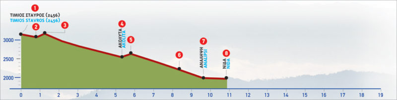
41 Timios Stavros (Psiloritis Summit) – Akolita – Nida
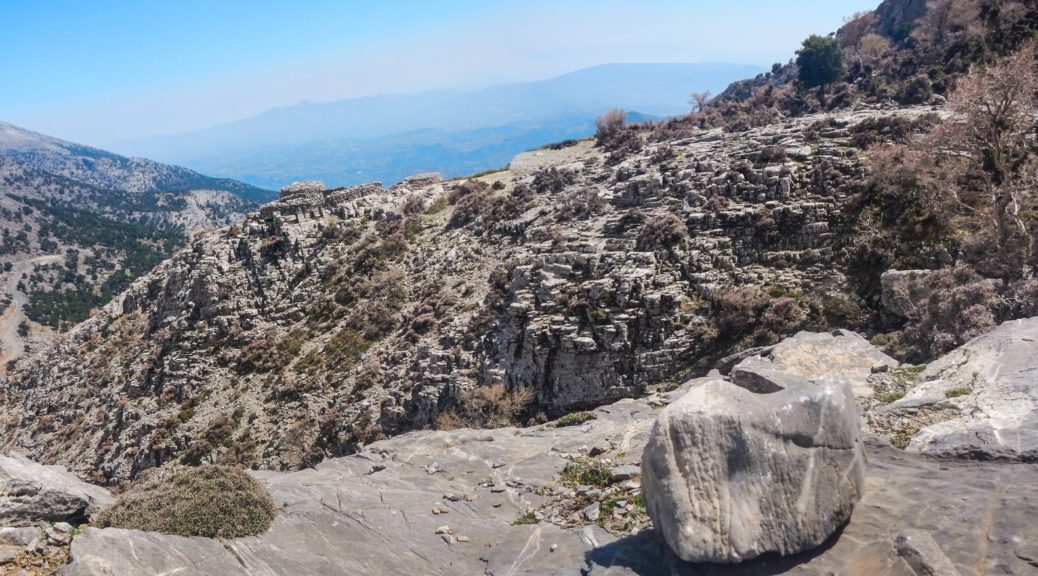
Timios Stavros is de naam van de top van de Psiloritisgebergte op Kreta eiland, and highest on the island. The mountain is also known as “Mount Ida“. From an altitude of 2456 m, the path descends steadily towards the second highest peak, Agathias (2424 m) tot aan de hoogvlakte van Nida. De kortste weg naar de top begint op het plateau van Laos Mygerou en duurt ongeveer 2 uur.
De E4-route van Timios Stavros naar Nida
To descend to Nίda from the summit of Timios Stavros (1) volgen we de berglijn tot aan het zadel (2) van Agathias. Daar aangekomen bereiken we (aan onze rechterkant, richting het zuiden) het voetpad dat naar beneden leidt naar de beschutting van de Bergbeklimmen Club van Rethymnon. We gaan rechtdoor, oostwaarts, over een licht stijgend pad, en bereiken de noordelijke helling van de top van Agathias (3). Wanneer dit deel van de route bedekt is met sneeuw en vorst, kan het erg gevaarlijk worden.
Na de noordoostelijke helling van Agathias Op de top volgen we een zuidoostelijke richting en passeren we een zwaluwengat. Onmiddellijk daarna volgen we, in gestage zuidoostelijke richting, de geul van de oostelijke helling van Agathiàs voor ongeveer 1 uur en 20 minuten, tot een klein plateau (4). Een bord is te zien waar het onduidelijke pad zich splitst.
Als we in zuidelijke richting gaan, komen we bij een groter plateau, genaamd Akolita, vanwaar we verder gaan naar de Grot Kamares en Dorp Kamares.
Voor de Plateau van NidaWe volgen de linker, oostelijke tak van het pad.
We lopen door het kleine plateau en beginnen licht te klimmen in de richting van het kleine zadel (5) dat voor ons te zien is; we komen er na ongeveer 10 minuten aan. Vanaf de berglijn is de rest van de Psiloritis massif, with its lower peaks, opens up eastwards, in the distance. Down below, the Plateau of Nίda can now be seen. We then follow the gully that opens up ahead of us, constantly descending towards the plateau, which little by little appears in its entirety.
Na ongeveer 1 uur afdalen verlaten we de geul en gaan we noordwaarts, over een relatief duidelijk pad dat ons naar een onverharde weg (6) leidt, die we naar rechts volgen. Dit brengt ons bij de kapel van Analipsi (7). Als we de onverharde weg ongeveer 600 m naar links volgen, komen we bij de Ideon AndronDe grot waar, volgens de mythe, Zeus werd geboren. Onder de kapel bevindt zich de waterbron van Analipsi. Vanaf dit punt dalen we af naar de Plateau van Nida (8), komen aan op de parkeerplaats van een verlaten uitziend gebouw, dat af en toe dienst doet als taverna.
De afdaling van de top van Psilorίtis aan de Plateau van Nida duurt in totaal ongeveer 3 uur en 20 minuten. De beklimming duurt daarentegen 4 uur en 30 minuten, bij redelijk weer.
| Padlengte | 10.5 km |
|---|---|
| Wandelduur | 3,5 uur |
| Wanneer wandelen | Lente, Herfst, Zomer |
| Pad Regio | Rethymno |