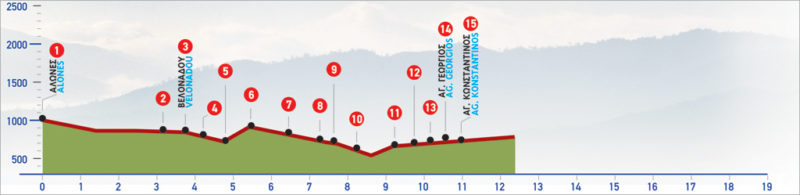
28 Alones – Agios Konstantinos
The small village of Alones, 37 km from Rethymno is built at an altitude of 510 meters and is located on southern Crete and the northern side of Kryoneritis mountain. In ancient times it was an important centre, due to its close proximity to Phoenecia the port city of Ancient Lappa (modern-day Argiroupoli). The path cross through lush green landscapes, imposing plane trees and the village of Velonado, and Moundros.
The E4 route from Alones to Agios Konstantinos
From Alones (1), we descend to the ravine and walk along for about 2 km.
Then we step onto the eastern bank, on a rather uphill dirt road (2), which, 600 m further along, leads us to the small agricultural settlement of Velonado (3). There, we reach the main road, which we follow northwards. After 550 m, we come to a small ravine and a bridge (4), on which an E4 sign can be seen. We ignore this sign; it directs to the section of the path that leads to the village of Moundros.
We continue for 250 m on the main road. Slightly before a left turn, we see an E4 sign on our right, as well as the beginning of an old path (5). We follow this path and descend to a small dry watercourse after which we begin to climb the slope in a northerly direction, towards a small saddle (6). Here a distinctive solitary tree can be seen. After the saddle, we reach a slightly downhill, bare slope, which we follow for approximately 700 m, in a due north direction. We then come to an area full of carob trees and bushes, where we see a sheepfold and a dirt road (7).
We follow the unsurfaced road for 950 m and we then come to an eastern turn (8) (in the first 100 m of which we come across the chapel of Panagia). We continue northwards and after 200 m we pass through an old, deserted settlement (9). Continuing along the dirt road, which by now begins to turn eastwards, we come first to a south-easterly branch and then to a south-westerly one. We ignore both and continue northwards. At the end of the unsurfaced road, we come to an animal shed (10) and begin to descend towards the bed of a verdant ravine, aiming for a hut on the opposite slope. This we must pass on our right-hand side, as we ascend the slope.
Passing through the ravine is quite difficult because there is neither a footpath nor any mark until the peak of the slope. There, we come to a cart track (11), which we follow in a north-westerly direction for about 250 m, until a crossroads (12), where we take the north-western fork. After 150 m (13), we follow a northerly direction; after another 250 m, we reach the first houses of the Agios Georgios village, as well as a track branching to the south-east, which we ignore. We continue northwards and arrive at Agios Georgios (14), and at the main road which we follow eastwards until the village of Agios Konstantinos (15).
| Path Length | 10.5 km |
|---|---|
| Hiking Duration | 3.5 hour |
| When to hike | Spring, Autumn, Summer |
| Path Region | Rethymno |