10 Poikilassos – Domata
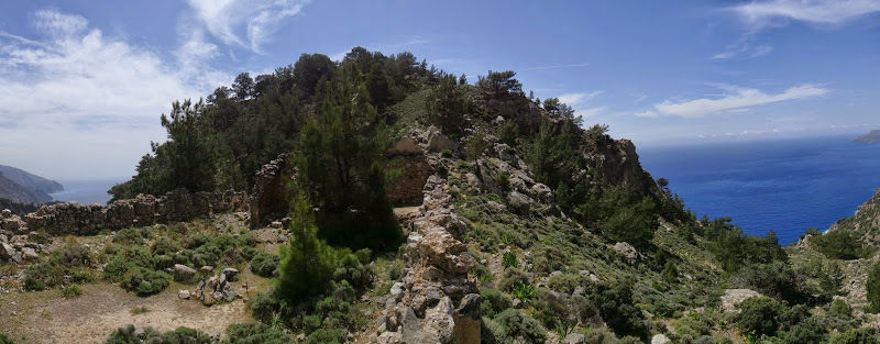
This route starts in the ancient town of Poikilassos on the southern coast of Crete. Information about the city is scarce and all that remains now are a few scattered ruins. Poikilassos marks a midpoint between Sougia and Agia Roumeli that crosses the E4 trail on the island. From Poikilassos, the path continues to Domata beach, an unspoiled and remote part of the island that few people get to see. The route is quite challenging and requires walking next to slippery cliffs. If you continue further on from Domata, you will arrive at the small town of Agia Roumeli. This is the endpoint of Samaria gorge where hikers rest for a few hours before catching a ferry to Hora Sfakion through Loutro.
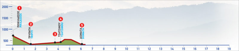
The E4 route from Poikilassos to Domata
From the fortress of Poikilassos (1), we begin to descend the steep slope for about 25 minutes, until the impressive gorge of Tripiti. The shaly nature of the slope that the path goes through makes the reverse route very difficult; the ascent requires about 50 minutes. First, we follow the stream bed in the gorge to the south, and after about 15 minutes we arrive at its outlet (2).
A few metres before the outlet, on the left-hand side of the gorge, a large niche is formed at the foot of the rock, where a small chapel can be seen. On the right of the chapel, on the cliff, there is an iron ladder that goes up to its top. Opposite the chapel, there is a small house with a cistern that has potable water. To exit the gorge, towards the sea, we follow the signs that lead us to a passage between the vertical cliffs and a large rock. It is best to avoid this passage, though, because landslides are frequent; instead, we bypass the rock, moving towards the coast, away from the cliffs as much as possible, until we see a large hole in the rock, which we pass through.
From this point on and for about15 minutes we walk along the beach, between labyrinthine rocks and caves, until we reach a small bay, where small farmers’ houses, as well as a pebble beach, are to be found. We keep walking by the coast, through sparse vegetation until we distinguish a makeshift pier on the right. Then we begin to ascend towards the edge of a steep slope, on a path which is hard to discern. Approaching the rocky top of the slope (3), for a section of about 50 m, the passage becomes difficult and dangerous to cross, so caution should be taken to ensure safe crossing. Proper equipment is required. After passing through the steep passage, we begin to ascend slightly on the ridge of the slope in a northern direction, towards a small gorge. We ignore a left, uphill turn-off and continue downhill, along the small steep gorge.
We leave the gorge and begin to climb slightly; there are interesting cave formations high up on our left-hand side. Down below on the rocky beach, the small cove of Tzatzimos (4) and a stone hut are distinguished. The path is clear and climbs up quite smoothly across a bush-covered slope, towards a small ridge; once we are there, we begin to descend eastwards, towards a gully. After crossing the gully, we descend to the stream, which is a continuation of the gorge of Klados. Now before us lies the breathtaking landscape of the bay of Domata and its spectacular beach (5).
This landscape is one of the most beautiful in Crete, and it owes its name to the different levels created by erosion (in Greek: δώματα– dómata = housetops, flat roofs). Pine trees prevail throughout the region. From here, northwards, and until the slopes of Mount Gigilos, lies one of the most unknown and inaccessible territories of Crete.
| Path Length | 6 km |
|---|---|
| Hiking Duration | 3 hour |
| When to hike | Spring, Autumn, Summer, Winter |
| Path Region | Chania |