Rethymno Road Trip: Rethymno – Plakias – Frangokastello
This route crosses through the Rethymno Prefecture, via one of the most imposing gorges of Crete. Along the way, you will have the chance to explore some of the most beautiful and famous beaches of southern Crete and visit sites of rich historical and archaeological interest.
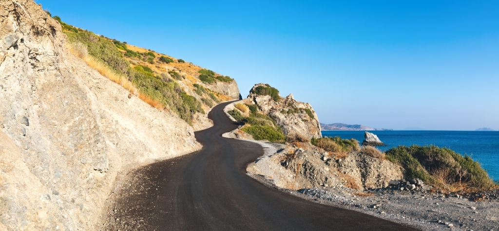
Following the road south, from Rethymno towards Spili, we make our first stop at Armeni, to visit a cemetery of the Late Minoan period, at the location of Prinokefala. Excavations here have unearthed more than 200 hewn chamber tombs. We continue our route to Mixorouma, where we can admire beautifully made items of basketry art. At the nearby village of Lambini, we can visit a chapel with exceptional Byzantine frescoes. We return to the junction and follow the road which leads to the narrow pass of the Kourtaliotiko gorge in a southerly direction. As soon as we pass it, we gaze upon one of the most beautiful areas of Crete, the valley of the Kourtaliotis river, and the location of the coastal settlement of Plakias.
Kourtaliotiko is one of the most beautiful gorges of Crete. Spectacular vertical cliffs can be seen on both its sides, reaching up as high as 300 metres at several spots. Because of the fact that many rare raptors nest here, the gorge is considered an important bird habitat. The valley of the Kourtaliotis river combines the impressive geomorphology of the gorge with an important ecosystem and a magnificent beach, where the small Preveli lake is located. On the banks of the lake, we find one of the two most significant palm forests of Crete. Up until the early ‘80s, the area was popular with the hippy community, but they were removed for the protection of the forest and of the estuary ecosystem. In 2010 an uncontrollable fire destroyed a large part of the forest; however, the palm trees soon showed signs of recovery and currently, the ecosystem is in a phase of regeneration. Nowadays the area is protected and free camping is prohibited.
In order to reach the monastery and the beach of Preveli, we turn left at the junction that we come upon after the outlet of the Kourtaliotiko gorge.
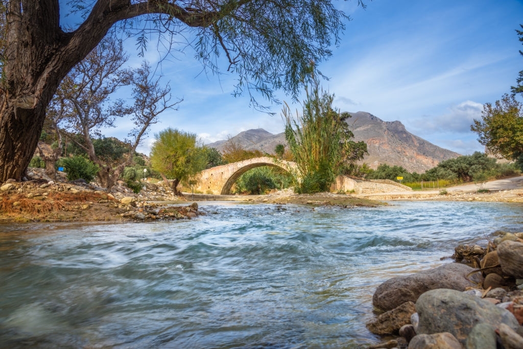
Following the road which leads to the lake, we encounter an old Venetian bridge where we come across Kato Monastiri (= lower monastery) and next to it, Piso Monastίri (= rear monastery), on the western side of Preveli lake. In the monastery, you will find a small yet quite exceptional Relics Museum. From the courtyard of the monastery, you can admire the incredible beauty of the scenery, with the Libyan Sea stretching out towards the south.
Leaving the monastery, we approach a junction on our hand side which leads to a spot where we can leave our car. From here we take the footpath which descends to the famous Preveli beach. After swimming, one can walk deeper into the lake area with the lush vegetation, and countless water springs. Back in the car, we continue towards the area of Plakias. The coastal settlement of Plakias has all necessary facilities, plus a long sandy beach. It is an ideal holiday destination and a starting point for exploring the surrounding area, where some of the most beautiful beaches of the island are to be found, such as Ammoudi, Schinaria, Damnoni and Souda.
Some of the beaches are organized while others are more suited to those seeking privacy, but they are all beautiful in their own way. Damnoni is more protected from the local winds. Schinaria features small white pebbles and deep waters. The water at Souda is rather cold because of a small river that flows into the sea; the beach, on the other hand, is quite green and Phoenix theophrastii palms grow on its western end. From Plakias, we ascend to Selia, where we can enjoy the view to the bay of Plakias from above and then follow the road to the area of Sfakia. The first two villages we encounter are Kato Rodakino and Pano Rodakino, and they are amphitheatrically built on the slope. This area has many beaches and beautiful landscapes with crystal-clear waters, such as Korakas, Polirizos, Klimata, Agia Marina and Peristeres, a spot popular with free campers. After Rodakino, the route passes by Argoules and Skaloti, as far as the flat plain where Fragkokastelo dominates the scenery, right next to the beach. The ruins of the monastery of Agios Charalambos can be seen very close to the fortress, above the spectacular beach of Orthi Ammos, (= upright sand), which as its name suggests has unique, almost vertical sand dunes.
Frangokastelo, which is well-known because of a beautiful Cretan legend, can serve as a starting point for exploring the whole area from Rodakino to Sfakia. This legend is about the “Drosoulites”, a mirage phenomenon which multiple residents have claimed they have witnessed. The visions occur very early in the morning on calm days, in the second half of May; this is around the anniversary of the Battle of Frangoskastello. The visions are shadows of horsemen, which the locals have named Drosoulites, meaning “morning dew silhouettes”.
Route Length: 84 km.
Region: Rethymno, St. Vasilios (South Rethymno), Sfakia (Chania)